Cassandra Bugir, Matt W. Hayward
The University of Newcastle

Click here to download the pdf of the poster.
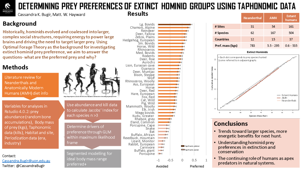
Prey preferences of extinct hominid groups.
As hominids have evolved and coalesced into larger, complex social structures, energy requirements to power large brains have driven the need to target larger prey. Technologies used to hunt evolved into projectile-type weaponry, resulting in less direct contact with prey. Using Optimal Forage Theory and honest signaling theory as the backgrounds for investigating extant and extinct hominid prey preference will look at variables such as prey abundance, killed/cut-marked bones, site location, and tools. Obtaining extinct hominid kill and prey abundance data from published and grey literary sources on assemblage sites (often from sink holes and confirmed by paleontologists and taphonomists) provides data for use in calculating the Jacobs’ Index value for each species hunted. For extant hunter-gatherers, we obtained kill and abundance data from primary literature and researcher collaboration using the same Jacobs’ Index value equation. Generalized linear models within a maximum likelihood framework determined the drivers of hominid prey preferences for each group studied. Understanding the role of humans as apex predators and their prey preferences is fundamental in reshaping anthropocentric attitudes and behavioral impacts.
Joel Mason, Anthony Barham, Tessa Bryant
Navin Officer Heritage Consultants

Click here to download a pdf of the poster.
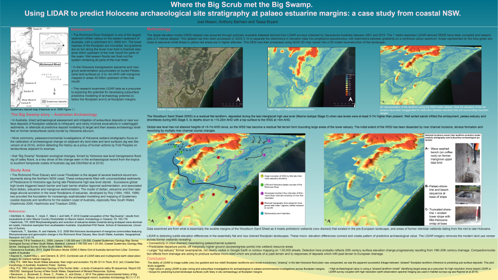
Where the Big Scrub met the Big Swamp. Using LIDAR to predict Holocene archaeological site stratigraphy at palaeo estuarine margins: a case study from coastal NSW.
Holocene sea level rise is recognised globally as a key factor in the formation of Holocene archaeological records at wetland margins. Relocation of human activity into novel mid-Holocene wetland edge ecotones, between drier land and swamp, are forcing functions for changes to site types, resource acquisition strategies and cultural behaviour reflected inter alia in e.g. waterlogged organics preservation, rock art, and midden composition.
Wetland margin archaeology often yields evidence of past human actions, which are poorly preserved on dry land sites. Dating potential, site preservation and stratification is often excellent. Wetland margins are also places where deposit modelling is critical to predicting impacts on buried prehistoric archaeology from infrastructure design (Historic England 2020). – The Richmond River floodplain is the largest Holocene alluvial – infilled estuarine embayment on the NSW coast. This pilot study examines the task of defining Potential Archaeological Deposit (PAD), at wetland margins using standard Google Earth satellite imagery, informed by engineering geotechnical data.
LIDAR is used to i) assess wetland edge topography ii) model past (pre-European) wetland extent and iii) develop GIS layers to predict PAD and archaeo-stratigraphic potential (as deposit models).
Excavations at three sites confirm model predictions, demonstrating LIDAR micro-topography layers can provide first-order prediction of sub-surface stratigraphy in Australian palaeo-estuarine wetland margins.
References
Historic England 2020 Deposit Modelling and Archaeology: Guidance for Mapping Buried Deposits. Swindon: Historic.
Kieran McGee
The University of Sydney

Click here to download a pdf of the poster.
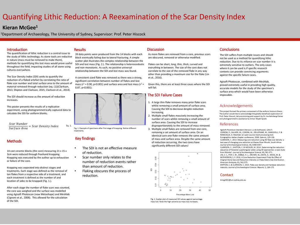
Quantifying Lithic Reduction: Reexamining the Scar Density Index.
The Scar Density Index (SDI) has been proposed as a method for calculating a lithic artefact’s lost mass due to continuous flaking. Such a method would be extremely valuable to the field of lithic technology. The SDI, as proposed by Clarkson and Shipton, asserts a correlation between the ratio of flake scars to surface area of a flaked artefact and the amount of material lost due to flaking. This research presents an independent test of this hypothesis. Fourteen identical, ceramic blocks were reduced using three simple flaking methods. Photogrammetric methods allowed for the fast, accurate measurement of the block’s surface area at each stage of reduction. The results indicate that the SDI is not an effective measure of lost mass. This is due to the SDI’s reliance on the gross scar number which indicates reduction events, as opposed to the amount of reduction, and the high variability in the number of flake scars over the life of reduction.
Liying Wang, Ben Marwick
University of Washington

Click here to download a pdf of the poster.
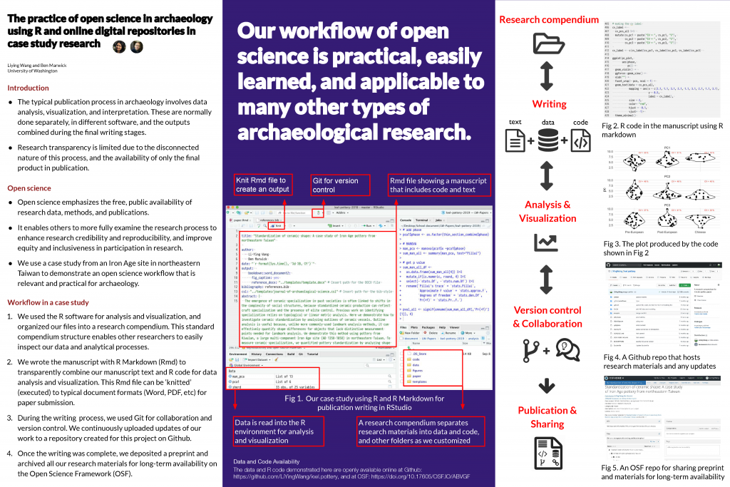
The practice of open science in archaeology using R and online digital repositories in a case study research.
A typical publication process in archaeology involves data analysis, visualization, and interpretation. These steps are normally done separately, in different software, and the outputs combined during the final writing stages. The disconnected nature of this process, and the availability of only the final product in publication, means that research transparency is limited. Open science emphasizes the free, public availability of research data, methods, and access to publications, to enable others to more fully examine the research process. This has become normal in many fields, and is important because it can enhance research credibility and reproducibility. Using a case study from an Iron Age site in northeastern Taiwan, we demonstrate an open science workflow in archaeology that is relevant and practical for archaeology. We show how to write the manuscript with R Markdown to combine our manuscript text and R code, Git for collaboration and version control, deposit a preprint, and finally archive all our research materials for long-term availability on the Open Science Framework (OSF). We used an R package as a research compendium to organize all digital materials of our project. This standard compendium structure enables other researchers to easily inspect our data and analytical processes. This workflow is practical, easily learned, and applicable to many other types of archaeological research. This practice of open science benefits not only researchers with increased impacts but also archaeology as a discipline through data sharing and reproducible research.
